Drinking water and groundwater protection

At least two boreholes, the production well and the injection well, are required to access the hot deep water at depths of several kilometers. During their construction, various aquifers, some of which are used for drinking water supplies, must be drilled through. To protect this valuable resource in the best possible way, higher water legislation provides certain regulations, that compliance with which is permanently monitored.

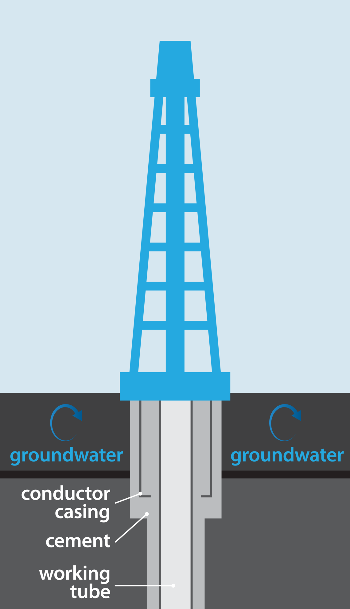
To ensure the best possible protection, so-called conductor casings are installed as part of the drilling pad construction. These casings are made of steel and are driven into the ground below the groundwater horizon in a similar way to sheet piling. They form a tight barrier between the drilling work and the surrounding near-surface layers. The first pipe section, several hundred meters long, is then cemented into the conductor casing, forming a triple-protected area (steel - cement - steel). This ensures that the hot deep water is always routed within a closed system. We only use its heat, not the water itself as in thermal bath.

A large and heavy drilling rig is used to drill the boreholes. As with any machine, there are mechanically moving parts that need to be lubricated. In order to protect the subsoil and drinking water from lubricants washed off by rain, the inner area of the drill pad, where the rig is located, is asphalted and designed so that liquids drain inwards into the so-called “drill cellar”.

This area is regularly drained by specialized companies. In the outer area of the drill pad, where trucks maneuver and office containers are parked, rainwater is drained into the sewer system.

For you. With all our energy.

Do you have questions about our products or our services? We are happy to provide you with a detailed consultation and any help you may require. Simply let us know what you need and our experts will take care of you as quickly as possible.

Please use our customer portal for issues such as name changes, meter readings, notifying us of a move, or something similar.


Request


Userdata

Email

Our locations

SWK Stadtwerke Kaiserslautern Versorgungs-AG

SWK Customer Service Center

Bismarckstraße 14
67655 Kaiserslautern

Business hours
Due to the corona pandemic, only open by phone appointment!

Tel.: (0631) 8001-1200
Fax: (0631) 8001-1000
Email: customerservice@swk-kl.de

SWK Mobilitätszentrale

Fruchthallstraße 14
67655 Kaiserslautern

Business hours
Due to the corona pandemic, this branch will remain closed until further notice!

Tel.: (0631) 8001-3530

SWK Energy Consulting Center

Brandenburger Straße 2
67663 Kaiserslautern

Appointments outside are possible
Tel.: (0631) 8001-1602

Technical Service, Asset Management

Karcherstraße 28
67655 Kaiserslautern
 

What other customers want to know

In general

Why are we exploring the potential of geothermal energy?

Geothermal energy presents a significant opportunity for our future heat supply. This technology not only provides a reliable, year-rounded source of heat in large quantities but is also locally available, long-term cost-stable, and fully renewable. By using geothermal energy, we can further expand and decarbonize our district heating supply, helping to shape a sustainable future for Kaiserslautern.

Was this answer helpful? Yes No
Who is behind Pfälzer Wärme?

Pfälzer Wärme is a brand of SWK Stadtwerke Kaiserslautern, representing progress, sustainability, and the exploration of geothermal potential in the Kaiserslautern region. With Pfälzer Wärme, we are driving forward the decarbonization of district heating and setting an example for a climate-friendly future. It brings together all activities related to geothermal energy, communicates our commitment to sustainable energy, and brings the vision of a CO2-free heat supply to life.

Was this answer helpful? Yes No

Geothermal energy

What is a fracture zone? Why is it important for geothermal energy?

Whether a rock layer is suitable for hydrothermal geothermal energy depends on several factors. High porosity, which refers to the presence of many small cavities in the rock, allows for the storage of water, like in a wet sponge. This deep water can then circulate underground along larger and smaller fracture zones (also known as fault zones). Through the boreholes, we try to hit precisely these ‘water motorways’.

Was this answer helpful? Yes No
How long can a geothermal plant be operated?

Geothermal plants are planned with an expected operating lifetime of at least thirty years. Based on current experience with pioneering plants in Riehen near Basel in Switzerland (commissioned in 1994), Erding near Munich (commissioned in 1998/2008) and Riem near Munich (commissioned in 2004), this seems realistic. Longer operation could also be possible, as demonstrated by the oldest European geothermal plant in Larderello, Italy, which has been generating electricity since 1913.

Was this answer helpful? Yes No
What is geothermal energy? Where does the heat from the depths come from?

It's hot inside our planet! Temperature in the Earth's core are estimated to exceed 5,000 degrees Celsius, and this heat is constantly flowing towards the Earth's surface. Additionally, heat is generated by the continuous decay of natural radioactive elements in the Earth's mantle and crust. This means that the heat stored within the earth is inexhaustible by human standards.

This means that the temperature steadily increases from just a few meters below the Earth’s surface. In Germany, this is an average of three degrees Celsius for every 100 meters of depth.

Was this answer helpful? Yes No
How hydrothermal geothermal energy works?

Hydrothermal geothermal energy uses natural hot deep water deposits to generate heat and electricity. To access this deep water, at least two boreholes are drilled. In the production well, the hot deep water is brought to the Earth's surface, where it passes through a heat exchanger within a closed pipe system and cools down in the process. Afterward, the water is then returned to the extraction layer through the injection well, where it heats up again. In contrast to thermal baths, we do not extract anything other than the heat it contains.

Was this answer helpful? Yes No
How many geothermal plants are there in Germany?

Geothermal energy has been successfully utilized as an energy source in various regions of Germany for over 20 years. Currently, there are 34 geothermal plants in operation. Of these, 31 are purely heating plants or combined heat and power plants, while three plants are exclusively focused on electricity generation.

The total installed heat output exceeds 450 megawatts.

Was this answer helpful? Yes No

Seismic exploration

Where and when are the measurements taken?

The seismic exploration is planned to take place during the low vegetation period from 2025 to 2026. We will communicate the exact date here as soon as it is known.

Was this answer helpful? Yes No
Can seismic measurements damage buildings?

Experience of recent years in cities such as Münster, Basel, and Munich has shown that seismic exploration can be carried out in densely populated areas without any problems. Information about buildings and supply lines is already obtained during the planning of the measurement lines.

Throughout the investigations, a safe distance from buildings is maintained, and ground vibrations are continuously monitored. The DIN 4150 standard, which regulates vibrations in buildings and their impact on structures, sets specific limit values that are strictly observed and verified through these measurements.

Was this answer helpful? Yes No
Who is permitter?

Permitters are our on-site contact persons. They obtain the necessary permits and approvals for the vibration vehicles to operate on paths and roads. Additionally, they handle communication with relevant authorities and local residents, for example.

Was this answer helpful? Yes No
How loud is the seismic exploration?

Although the seismic trucks are soundproofed and comply with the guidelines, residents along the measurement routes may still experience significant noise pollution for around one to two hours.

We apologize for any inconvenience and appreciate your understanding during the exploration.

Was this answer helpful? Yes No
What does a seismic exploration feel like?

The vibrations generated by the vibro-trucks can be felt in the immediate vicinity of the vehicles as a tingling sensation in the soles of the feet. Even in buildings directly next to the measuring track, the vibrations are comparable to those of a passing streetcar.

Accompanying measurements of ground vibrations ensure that the limit values defined in the DIN 4150 standard on vibrations in buildings and effects on structures are complied with.

Was this answer helpful? Yes No
To what extent are roads and paths affected by the seismic exploration?

Weighing between of 20 to 30 tons, the vibro-trucks are comparable in size to large trucks or harvesters. The lighter vehicles are approved for regular road traffic, while special permits are required for heavier trucks. Field and forest roads can usually also be used without damage. However, in the event that road damage does occur as a result of the vibrations, funds have been allocated for repairs.

Was this answer helpful? Yes No
Who can I contact if I notice any damage?

If any damage is caused by the 3D seismic exploration, please report it to our permitting team. They will document and forward the case. Independent experts will then check the damage report before the costs are settled.

Was this answer helpful? Yes No
Are there any impairments or dangers associated with the seismic exploration?

Seismic exploration was developed as a minimally invasive method to provide an initial insight into rock formations. Aside from a brief noise disturbance, there are no adverse effects on people or nature. The vibrations generated during the exploration are similar to those felt from a passing streetcar by bystanders.

The strength of the vibrations is also monitored using ground vibration measurements to ensure compliance with DIN 4150 (vibrations in buildings and effects on structures). This serves to prevent damage to buildings.

The measurement team, consisting of three to five vehicles driving in convoy, can impact traffic flow. The measuring team is comparable to a moving construction site and may cause traffic jams and other obstructions. We apologize for any inconvenience this may cause.

Was this answer helpful? Yes No
What is 3D seismic exploration? How does the technology work?

Seismic exploration can be compared to an ultrasound image of the subsurface. So-called seismic or vibro-trucks move along measurement lines, stop at predetermined points to send slight vibrations (sound waves) into the ground through a hydraulically lowerable vibrating plate beneath the vehicle. These vibrations are reflected at the boundaries between different rock layers and are recorded by small measuring devices on the surface, known as geophones.

The evaluation of the data results in a 3-dimensional image of the subsurface, providing valuable information about the different rock layers and fracture zones.

Was this answer helpful? Yes No
What is the difference between 2D and 3D seismic?

2D and 3D seismic operate on the same basic principles, with the main difference being the orientation of the seismic lines.

In 2D seismic, the geophones are laid out along a single line, and measurements are taken in just one direction (length). The resulting subsurface image is two-dimensional (length and depth), providing an initial overview of the depth and thickness of the rock layers.

In 3D seismic, as planned in Kaiserslautern, the geophones are laid out in a grid pattern (square or rectangle). Seismic exploration take place along lines that are oriented in length and width. The result is a three-dimensional subsurface model (length, width, depth), offering a more detailed view of the subsurface, allowing it to be mapped in much greater detail.

Was this answer helpful? Yes No