We carry out what is known as 3D seismic surveying. This is a technique that works in a similar way to an ultrasound scan. We send sound waves into the ground. The result is a detailed image of the geological structures and possible flow paths within the earth’s layers.
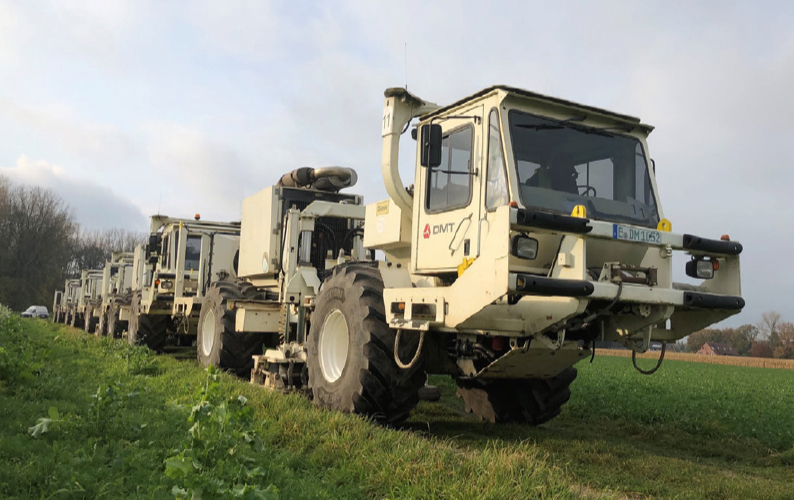
Special vehicles, known as vibro-trucks, are used for this purpose. These lorries are fitted with vibrating plates. These are lowered onto the ground to generate controlled vibrations (sound waves). The reflected sound waves are recorded by geophones on the surface. We can then create a precise 3D model of the earth’s layers.
This is how we proceed:
1. Preparation for the measurements:
We have planned the routes and obtained the necessary permits. This task was carried out by IPS Informations- & Planungsservice GmbH from Celle (email: lutrina@ips-celle.de). On behalf of SWK, the IPS team obtained permission to use roads and access private land.
2. Carrying out the 3D seismic survey:
We expect to begin the seismic surveys in mid-November 2025. From then on, the vehicles will be on the move in the region.
How 3D seismic surveys work:
Every 30 metres, the vibro-trucks stop at measurement points and send sound waves deep into the ground via a vibrating base plate. The sound waves are reflected at the boundaries between rock layers, and this echo is recorded by measuring devices – known as geophones – distributed across the surface.
The geophones are laid out over a wide area along open roads and paths and are located via GPS. The measuring devices, with the data stored within them, are extremely valuable to us, which is why it is important that they remain in place.
The convoy of vibro-trucks moves very slowly – much like a moving roadworks site. This may therefore cause traffic disruption.
The vehicles can also be heard clearly, and the vibrations can be felt in the immediate vicinity. However, the measurements pose no danger, and we monitor the situation at all times to ensure that no critical vibrations occur in buildings.
3. Data analysis:
The experts analyse the collected data to create a detailed 3D model of the water-bearing rock layers. Based on the results, we will decide whether and where to carry out drilling to harness geothermal energy.
We rely on your support and understanding for this important project. The municipal utilities therefore ask that you please leave the geophones in place. We apologise for any inconvenience caused by the measurements. With ‘Pfälzer Wärme’, we aim to develop a sustainable, independent and future-proof source of heat for our region.